
Charleston, SC, September 29, 2025
News Summary
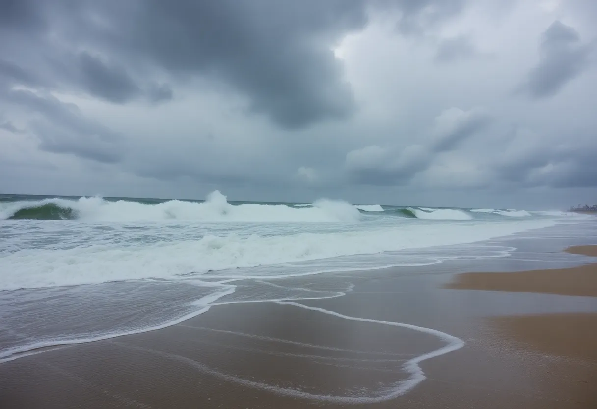
The National Weather Service has issued a high surf advisory for Charleston as Hurricane Erin approaches South Carolina. Dangerous surf conditions are expected with waves of 5 to 6 feet. Swimmers are urged to stay out of the water due to rip currents, as Hurricane Erin, classified as a Category 2 storm, brings serious surf hazards. The advisory remains in effect until Saturday morning, with peak wave heights expected on Wednesday. Residents are advised to remain vigilant and adhere to safety guidelines.
Charleston, SC – A high surf advisory has been issued by the National Weather Service (NWS) for the Charleston area as Hurricane Erin approaches South Carolina. The advisory, which indicates dangerous surf conditions, became effective at 8 p.m. on Monday, lasting until 8 a.m. on Saturday. It encompasses Coastal Colleton, Coastal Jasper, Beaufort, and Charleston counties.
As the effects of Hurricane Erin begin to be felt along the coast, large breaking waves of 5 to 6 feet are anticipated in the surf zone. This storm, classified as a dangerous Category 2 hurricane with sustained winds of 105 mph, is forecasted to pass over 400 miles off the South Carolina coast. Nevertheless, the swell generated by Hurricane Erin is expected to increase wave heights significantly, elevating concerns for swimmers and surfers alike.
Swimmers and surfers are warned that dangerous conditions may arise along the coastline, including localized beach erosion. The NWS has stressed that inexperienced swimmers should refrain from entering the water due to the heightened risk of rip currents, which can potentially sweep individuals into deeper waters. If caught in a rip current, swimmers are advised to remain calm and float, as swimming against the current can lead to exhaustion. Instead, they should attempt to swim parallel to the shore to escape the current and call for assistance if they are unable to do so.
The rip currents and high surf conditions are expected to persist throughout the week as waves are predicted to rise from 2-3 feet to between 5-7 feet starting Tuesday. The peak conditions are expected on Wednesday, with wave heights reaching an estimated 6-8 feet before gradually declining.
In conjunction with the advisory, the local weather forecast indicates mostly clear skies overnight with temperatures dropping to the mid 70s. The forecast for the upcoming week includes mostly sunny conditions on Tuesday with highs around 91°F, transitioning to partly cloudy on Wednesday and Thursday with similar high temperatures. Toward the end of the week, clouds may increase with isolated rain and storms anticipated over the weekend.
While Hurricane Erin’s expansive cloud canopy is reported to reach from the Bahamas to southern New England, the direct impact on Charleston is expected to be limited to surf conditions. Residents along the coast are urged to remain vigilant and follow safety advisories during this period of heightened surf activity.
Weather Forecast Summary
- Tuesday: Mostly sunny, high around 91°F, low 75°F.
- Wednesday: Partly cloudy, high 92°F, low 75°F.
- Thursday: Partly cloudy, high 92°F, low 76°F.
- Friday: Sun and clouds with isolated rain/storms, high 89°F, low 75°F.
- Saturday and Sunday: Sun and clouds with isolated rain/storms, high around 86°F to 88°F, lows 73°F.
Key Features of Hurricane Erin
| Feature | Details |
|---|---|
| Category | 2 |
| Winds | 105 mph |
| Distance from SC Coast | 400 miles |
| Wave Heights | 5-7 feet (peaking at 6-8 feet) |
FAQ
What is the duration of the high surf advisory?
The advisory is in effect from 8 p.m. Monday until 8 a.m. Saturday.
Which counties are affected by the high surf advisory?
The advisory covers Coastal Colleton, Coastal Jasper, Beaufort, and Charleston counties.
What are the expected wave heights?
Large breaking waves of 5 to 6 feet are expected in the surf zone.
What should swimmers do if caught in a rip current?
If caught in a rip current, swimmers should relax and float, attempt to swim parallel to the shore, and call for help if unable to escape.
What is Hurricane Erin’s current classification?
Hurricane Erin is categorized as a dangerous Category 2 storm with winds of 105 mph.
Deeper Dive: News & Info About This Topic
HERE Resources
Dense Fog Advisory Issued in South Carolina
Tropical Depression Nine Brings Threats to Coastal South Carolina
Tropical Storm Humberto and AL94 Raise Concerns for South Carolina
NWS Issues Warning for Dangerous Rip Currents in Coastal Areas
Rip Current Warning Issued for Coastal Jasper and Beaufort County
Beaufort County Enhances Hurricane Preparedness with AI Traffic Cameras
Coastal Flood Advisories Issued as Hurricane Erin Approaches
Charleston Faces Coastal Flood Advisory as King Tide Approaches
High Risk of Rip Currents as Hurricane Erin Approaches Charleston
Rip Current Warning Issued for Charleston, SC Beaches
Additional Resources
- The State
- Wikipedia: Hurricane Erin
- Live 5 News
- Google Search: Hurricane Erin
- Fox Weather
- Encyclopedia Britannica: Hurricane Erin
- ABC News
- Google News: Hurricane Erin
- Greenville Online