Charleston, January 25, 2026
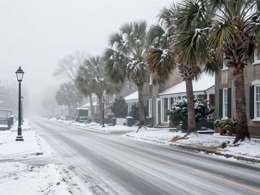
Charleston and surrounding counties in South Carolina are currently experiencing a combination of freezing rain, ice accumulation, and dense fog, significantly disrupting travel and daily life. With winter weather alerts in effect, residents are advised to exercise extreme caution, as the National Weather Service has issued multiple warnings for hazardous conditions, including reduced visibility and slick roadways. Authorities emphasize the importance of postponing non-essential travel as the winter storm continues to impact the region.
Charleston, South Carolina Braces for Continued Winter Weather and Dense Fog
A combination of freezing rain, ice accumulation, and dense fog is significantly impacting travel and daily life across several South Carolina counties, including the Charleston metropolitan area, as winter weather alerts remain active. Residents are urged to exercise extreme caution and consider postponing non-essential travel through early Sunday morning and into Monday. The National Weather Service has issued various advisories and warnings for the region, highlighting hazardous conditions on roadways and reduced visibility.
Current Alerts and Affected Areas
A weather alert for dense fog is currently active for the Lowcountry until early Sunday, January 26, 2026. This alert specifically covers Coastal Colleton, Coastal Jasper, Beaufort, and Charleston counties. Authorities have advised that areas of fog, some locally dense, will significantly reduce visibility, making driving conditions treacherous.
In addition to fog, a Winter Weather Advisory has been updated and remains in effect for several inland and coastal counties. An advisory issued on January 23, 2026, and effective until January 25, 2026, at 1:00 PM EST, by NWS Charleston SC, covered Allendale, Dorchester, Hampton, Inland Berkeley, and Inland Colleton Counties for freezing rain and freezing drizzle with total ice accumulations up to one tenth of an inch. Another updated Winter Weather Advisory, as of Sunday, January 25, 2026, at 6:15 a.m., affects Dorchester, Hampton, Inland Colleton, Allendale, Tidal Berkeley, and Charleston Counties. These conditions are expected to persist from 4 PM EST on Sunday, January 25, 2026, until 7 AM EST on Saturday, January 26, 2026, bringing the potential for freezing rain and ice accumulation.
The National Weather Service Columbia, SC, also issued an Ice Storm Warning at 1:12 AM EST on Sunday, January 25, 2026, indicating the severity of the ongoing winter storm. This warning applies to several counties in central South Carolina, including Richland County, with the peak period of ice accumulation expected from Saturday evening into Sunday evening. This underscores a broader State-level concern for icy conditions across the South Carolina Midlands, where significant ice accumulations could linger for several days, posing dangerous travel conditions and potential widespread power outages. Freezing drizzle was reported across several South Carolina counties as of Saturday evening, January 24, 2026.
Travel Advisories and Road Conditions
State officials across North Carolina have urged people to avoid travel as a powerful winter storm moved across the state late Saturday through Sunday. A Winter Storm Warning is in effect for most of central North Carolina, with a Winter Weather Advisory for Wayne, Sampson, and Cumberland Counties, as sleet and freezing rain are expected. Significant accumulations of ice and sleet are possible across the Piedmont of central North Carolina, and roads, especially bridges and overpasses, are likely to become slick and hazardous. This State-level advisory for North Carolina highlights the regional impact of the storm system, which is also affecting parts of South Carolina.
For South Carolina, residents in affected areas are advised to prepare for slippery roads and to significantly slow down, exercising extreme caution when driving. The presence of both freezing precipitation and dense fog creates a particularly hazardous environment for motorists. Previously, in December 2025, icy conditions and fog led to multiple crashes and temporary closures of major thoroughfares in Charleston, including the Don Holt Bridge and Cogsgrove Bridge, highlighting the dangers of such weather combinations. While those bridges have since reopened, the historical context serves as a reminder of potential risks. Authorities, including the Columbia-Richland Fire Department, encourage citizens to stay informed and avoid unnecessary travel. Flight disruptions, including numerous cancellations, were reported at Columbia Metropolitan Airport on Sunday morning, January 25, 2026, due to freezing rain and icy conditions in the Midlands.
Anticipated Impacts and Safety Measures
The forecast indicates potential for total ice accumulations of up to one tenth of an inch in some areas, including Dorchester, Hampton, Inland Colleton, Allendale, and Tidal Berkeley counties. The NWS also reports major to extreme impacts expected in North Georgia due to significant ice accumulations of 0.5-1.0 inches with locally higher amounts possible, accompanied by gusty winds. This level of ice accumulation can lead to slick surfaces, making walking and driving perilous, and potentially causing power outages due to weight on power lines and tree branches. South Carolina officials have warned residents to be prepared for several days without power if forecasts pan out.
Emergency services and local authorities are monitoring the situation closely. Citizens are encouraged to have emergency items ready for their homes in case of power outages, including flashlights and extra batteries. When venturing out, dressing in layers and wearing appropriate footwear to prevent slips and falls is recommended. Bitterly cold air is expected to follow the storm early next week, with low temperatures potentially reaching single digits in parts of the Upstate by Tuesday morning.
Background on Recent Weather Events
This period of challenging weather follows a pattern of recent wintry conditions for the region. In early December 2025, the National Weather Service Charleston issued its first-ever Freezing Fog Advisory for Charleston and Tidal Berkeley counties, signaling an unusual and dangerous weather phenomenon. This earlier event also contributed to icy roads and traffic incidents, underscoring the ongoing need for vigilance during winter weather. Additionally, a fog alert was active for the Lowcountry just four days prior to the current alerts, affecting Coastal Colleton, Tidal Berkeley, and Charleston County. A large, long-duration winter storm began affecting the Southern Rockies and Plains on Friday, January 23, 2026, spreading eastward to the Mid-Atlantic and New England over the weekend, with winter storm warnings, watches, and advisories stretching across the eastern United States. The current storm promises to create problems across much of the eastern half of the nation, including South Carolina, during the weekend of January 24-25, 2026.
Frequently Asked Questions
- What are the current weather alerts for the Lowcountry, South Carolina?
- A weather alert for dense fog is currently active for the Lowcountry until early Sunday, January 26, 2026, covering Coastal Colleton, Coastal Jasper, Beaufort, and Charleston counties. Additionally, an updated Winter Weather Advisory for freezing rain and ice accumulation is in effect for Dorchester, Hampton, Inland Colleton, Allendale, Tidal Berkeley, and Charleston Counties from 4 PM EST on Sunday, January 25, 2026, until 7 AM EST on Saturday, January 26, 2026. An earlier Winter Weather Advisory was issued on January 23, 2026, by NWS Charleston SC, for Allendale, Dorchester, Hampton, Inland Berkeley, and Inland Colleton Counties, effective until January 25, 2026, at 1:00 PM EST. An Ice Storm Warning was also issued by the National Weather Service Columbia, SC, on Sunday, January 25, 2026, for several counties in central South Carolina, including Richland County.
- Which specific areas are affected by the dense fog advisory?
- The dense fog advisory applies to Coastal Colleton, Coastal Jasper, Beaufort, and Charleston counties in the Lowcountry.
- Which counties are under a Winter Weather Advisory for freezing rain and ice?
- An updated Winter Weather Advisory for freezing rain and ice accumulation includes Dorchester, Hampton, Inland Colleton, Allendale, Tidal Berkeley, and Charleston Counties, active from 4 PM EST on Sunday, January 25, 2026, until 7 AM EST on Saturday, January 26, 2026. An earlier advisory also covered Allendale, Dorchester, Hampton, Inland Berkeley, and Inland Colleton Counties.
- What kind of ice accumulation is expected?
- The forecast indicates potential for total ice accumulations of up to one tenth of an inch in some affected areas. In North Georgia, significant ice accumulations of 0.5-1.0 inches with locally higher amounts are expected.
- Are there any travel advisories for North Carolina related to this storm?
- Yes, State officials in North Carolina have urged people to avoid travel as a powerful winter storm moved across the state late Saturday through Sunday. A Winter Storm Warning is in effect for most of central North Carolina, with a Winter Weather Advisory for Wayne, Sampson, and Cumberland Counties.
- What impacts are expected from the Ice Storm Warning in central South Carolina?
- The Ice Storm Warning for central South Carolina, including Richland County, anticipates significant ice accumulations, dangerous travel conditions, and potential widespread power outages, with very cold temperatures expected early next week.
Key Features of Winter Weather Alerts in South Carolina and Surrounding Regions
| Weather Event | Affected Areas | Duration / Timing | Key Impact / Accumulation | Scope |
|---|---|---|---|---|
| Dense Fog Alert | Coastal Colleton, Coastal Jasper, Beaufort, Charleston counties | Until early Sunday, January 26, 2026 | Reduced visibility, treacherous driving | Regional (SC Lowcountry) |
| Winter Weather Advisory (Freezing Rain/Ice) | Dorchester, Hampton, Inland Colleton, Allendale, Tidal Berkeley, Charleston Counties | 4 PM EST Sunday, January 25, 2026, to 7 AM EST Saturday, January 26, 2026 | Potential for freezing rain and ice accumulation | Regional (SC Counties) |
| Winter Weather Advisory (Freezing Rain/Drizzle) | Allendale, Dorchester, Hampton, Inland Berkeley, Inland Colleton Counties | January 23, 2026, to January 25, 2026, 1:00 PM EST | Total ice accumulations up to one tenth of an inch | Regional (SC Counties, NWS Charleston SC Area) |
| Ice Storm Warning | Several counties in central South Carolina, including Richland County | Saturday evening into Sunday evening, January 24-25, 2026 | Significant ice accumulations, dangerous travel, widespread power outages | State-level (SC Midlands) |
| Travel Advisory (Avoid Travel) | Across North Carolina | Late Saturday through Sunday, January 25, 2026 | Powerful winter storm, travel discouraged, slick/hazardous roads, widespread power outages possible | State-level (North Carolina) |
| Expected Ice Accumulation | Dorchester, Hampton, Inland Colleton, Allendale, Tidal Berkeley counties | Ongoing | Up to one tenth of an inch | Regional (SC Counties) |
| Expected Ice Accumulation (North Georgia) | Much of North Georgia | Sunday, January 25, 2026, to Monday, January 26, 2026 | 0.5-1.0 inches with locally higher amounts, major to extreme impacts | Regional (North Georgia) |
| Flight Disruptions | Columbia Metropolitan Airport (CAE) | Sunday morning, January 25, 2026 | Cancellations due to freezing rain and icy conditions | Local (Columbia, SC) |
Deeper Dive: News & Info About This Topic
HERE Resources
Beaufort County Deputies Discover Stolen Firearm During Animal Control Operation
Tragic Start to the Year in Beaufort County
Bluffton and Beaufort Celebrate Fall with Community Events
Community Mourns the Passing of Elaine Yount Gantt
Coastal Flood Advisory Issued for Beaufort County
Flood Advisory Canceled for Beaufort and Jasper Counties
Beaufort County Prepares for Hurricane Helene and Flooding
Beaufort County Residents Advised to Prepare for Hurricane Season
Beaufort County Man Found Safe After Disappearance
Beaufort and Jasper Counties Urge Hurricane Preparedness